The Prairie Spirit Trail
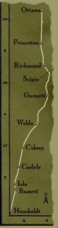
The Prairie Spirit Trail in eastern Kansas is a 52-mile-long path through small towns, shaded woodland canopy, and scenic prairies alive with wildflowers (and wildlife!), and running beside streams, rivers, neatly-tended fields and family farms. Built on the railbed of the old Leavenworth, Lawrence and Fort Gibson Railroad, the trail offers easy grades for hikers and bikers alike. The trail runs north/south between Ottawa and Iola, connecting to the Flint Hills Nature Trail in the north, and the Southwind Rail Trail in the south. The trail is paved within Ottawa, Garnett, and Iola, with rural sections having a hard-packed limestone surface. The Prairie Spirit Trail State Park is managed by the Kansas Department of Wildlife, Parks, and Tourism.
Bike Prairie Spirit helps bicyclists explore this popular trail, providing a comprehensive informational resource, including Guides to all the communities along the trail, as well as Trail Maps, Elevation Charts, Mileage Charts, and a Services and Support Directory that will help you find food, drink, and points of interest along the trail.
You can discuss the Prairie Spirit Trail with other riders in our Discussion Forum, view photos taken along the trail by other users, and check out the best times for segments of the trail.
Here’s where you’ll find what you need for your journey on the Prairie Spirit Trail!